We move into fuzzy inference systems this week as another more flexible, less sensitive and more powerful version of habitat suitability models when compared with their habitat suitability curve driven counterparts.
Resources
Lecture & Slides
Fuzzy Habitat Suitability Models - Lecture
1 hour and 23 minutes totalFirst three suggested (~48 minutes); Last 35 minutes case study for CHaMP specifics (optional)
Homework Assignment
You are going to build (from scratch) a fuzzy inference system for a spawning habitat suitability model for steelhead (based on your “expert” judgement). We’re not seeking the perfect model as much as we are building famliarity with the steps in building the FIS and applying it to specific reach under a specific flow condition (represented by a steady state hydraulic simulation from one reach).
1. Build Inference System & Specify Membership Functions
We started this homework in class. You were asked to come to class (see lecture) with a Google Sheet spreadsheet with a table representing your inference system.
- Open up Google Sheets in Browser
- Make an inference system (i.e. rule table) for a two input fish habitat model for spawning steelhead
- Use inputs & categories of:
- Depth: Shallow, Medium, Deep
- Velocity: Slow, Medium, Fast
- Use output of Habitat Suitability with categories of Poor, Moderate, Good. Note - You can add more categories or tweak the above, but you will need to adjust number of rules.
You will submit a shared-link to your Google Sheet.
2. Translate your FIS into a real FIS
The GCD has a FIS Library that uses the same standard as the Matlab Fuzzy Logic Toolbox. Similar libraries exist for R (e.g. FuzzyR) and Python (e.g. SciKit-Fuzzy).
In the video below , we show you how to do this using the text editor in the FIS Library of GCD (you can also do it in any text editor). CAUTION, the FIS needs to be formatted exactly the same way and extra spaces or breaks will cause it to crash. For this reason, we edited an existing TS_ZError_PD_SLP_deg.fis for a DEM error model just to get us started on proper syntax.
You will not need to submit your *.fis text file as when you sumbit a zip file of your GCD project, it will contain a copy of the file.
3. Apply your FIS to a real CHaMP Survey of a Real Site
Instructions for running your FIS in GCD
This tutorial is for using GCD and RAVE AddIns to ArcGIS 10.X. You can use the GCD StandAlone to get model to work, and forgo the GIS symbology (you can manually symbolize this). You will need a free account that you create on data.riverscapes.xyz and request access to the Asotin Warehouse.
- Download a CHaMP Topo Survey from Asotin Warehouse. See this video if you need a reminder as to how.
- Download a CHaMP hydraulic model for the exact same visit (i.e. same survey year and site).
- Load your *.fis file into the GCD FIS Library.
- Make a new GCD project.
- Add your DEM from the Topo project to the GCD project.
- Add your depth and velocity rasters as associated surfaces to the DEM.
- Calculate and "Error Surface" using your FIS and the depth and velocity rasters as inputs to run your model.
Building a Fuzzy Ecohydraulic Model
18 minutes totalTutorial on using GCD to "run" your FIS
You will turn a zipped up copy of your GCD project with the ecohydraulic model and results in it.
4. Answer the Following Questions
- Does your model produce coherent results (spatially) that make sense? Explain why or why not.
- How would you calculate total weighted useable area for your simulation? (optional to calculate it)
- How would you explore if habitat suitability is changing at the Asotin CHaMP site you chose?
What to turn in:
- Please include a 1-2 page write up summary. Explain what you did, and include (a) figure(s) that shows your inputs (velocity and depth maps) as well as your output. In the summary answer the above questions.
- Also submit a shared-link to your Google Sheet.
- Submit a zip file or a link to a zip file of your GCD project.
Alternative Method using Habitat Model Software
 Another way to complete both the assignment above and apply some habitat suitability curves is to use the Habitat Model Software, which we had North Arrow Research developed back in 2015 (WARNING: No longer supported and some broekn links). You can download the FHM here. To install (only on Windows), click on the
 More info link then Run Anyway.
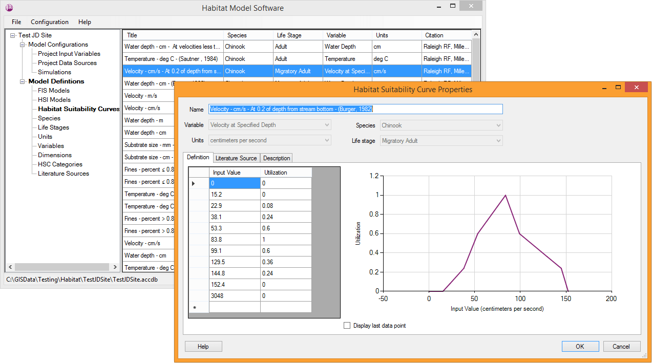
The stand-alone has no mapping interface, but allows you to work with *.csv, *.shp shapefiles, or rasters as inputs and outputs, and allows the specification of your own FIS models (also has some pre-loaded) as well as HSCs and HSIs if you want to use those. In the video below, I was unable to get the rasters to work, but was able to get the CSVs to work. This software also allows easy batching of multiple habitat models for the same runs.
Post any issues you find here.